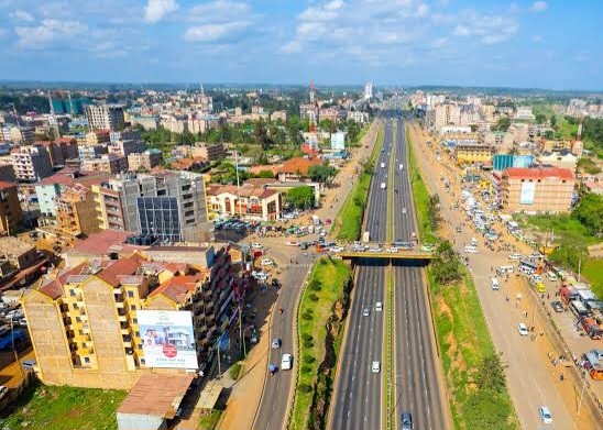
In Nairobi, the alignment of matatu routes with road infrastructure, population growth, and suburban expansion is quietly shaping the city’s property market. For investors, developers, and homebuyers, understanding the correlation between transport corridors and real estate demand is increasingly vital. This is the hidden algorithm behind Nairobi matatu routes and property prices, showing how commuter behavior predicts which neighborhoods will experience the next wave of growth.
Public service vehicles (PSVs), particularly matatus, remain the backbone of urban mobility in Nairobi. Recent studies indicate that areas with frequent and reliable matatu connections consistently attract higher residential and rental demand, driving up property value growth along matatu routes Nairobi. In practical terms, accessibility to matatu stages is becoming as important as proximity to roads or commercial hubs for buyers and investors alike.
Why Matatu Connectivity Drives Real Estate Growth

- Commuter Behavior Predicts Housing Demand
The majority of Nairobi residents depend on matatus for daily travel. Corridors with heavy commuter loads naturally create demand for nearby housing. Areas that allow residents to reach the CBD or industrial zones in 30–45 minutes are highly sought after, making them prime candidates for Nairobi real estate near public transport. - Satellite Towns Benefit from Route Expansion
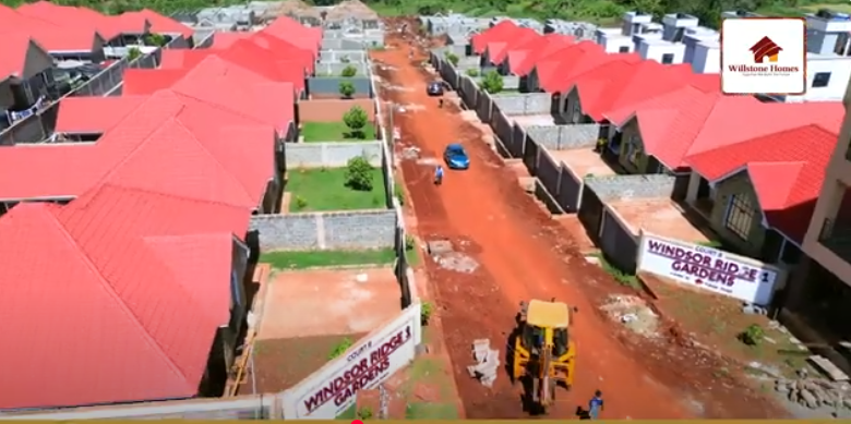
Suburbs like Ruiru, Juja, Thika, and Kitengela have seen rapid development where matatu services are frequent. Improved accessibility reduces travel time, increasing desirability and boosting property value growth along matatu routes Nairobi. - Investor Confidence Follows Transport Patterns
Developers often use matatu route data as a proxy for population density and growth trends. By analyzing peak-hour ridership, they identify emerging neighborhoods before traditional real estate metrics reflect increased prices — essentially using matatu routes as market predictors.
Key Matatu Corridors Influencing Nairobi Real Estate

Recent 2025 transport surveys highlight the most influential routes for residential demand:
| Corridor / Zone | Key Matatu Routes | Real Estate Trend | Observations |
|---|---|---|---|
| Thika Road → Ruiru & Githurai | Matatus connecting suburbs to CBD | Rising property value growth along matatu routes Nairobi | High commuter demand; infrastructure upgrades support growth |
| Juja Road → Juja Town | Multiple matatu lines linking estates | +4.2% Q1 2025 price growth (Swalanyeti.co.ke) | Affordable entry for first-time buyers; strong rental market |
| Mombasa Road → South-East Suburbs | Frequent matatus to industrial zones | Moderate but steady growth | Mixed-use development; proximity to work hubs |
| Jogoo Road → Eastlands | Industrial and residential corridors | Consistent demand among renters | High turnover; rental income stable |
| Northern Kiambu (Muthaiga–Kiambu–Ndumberi) | Emerging matatu connections | Early investor interest | Road upgrades expected to enhance Nairobi real estate near public transport |
How Buyers Use the Data
Homebuyers increasingly consider both price and accessibility. Those seeking best suburbs in Nairobi near matatu routes are prioritizing:
- Travel time to work or school (<45 mins)
- Frequency and reliability of matatu service
- Safety and convenience of walking routes to stages
- Proximity to essential services such as supermarkets, hospitals, and schools
The combination of these factors often determines whether a suburb becomes a high-demand residential zone.
Read Also: Women-Only Saccos: The Silent Revolution Driving New Housing Estates in Kenyan Suburbs
Developers Respond with Strategic Planning
Developers are now designing projects with matatu accessibility in mind:
- Proximity to Existing Routes – Placing estates within walking distance to high-frequency stages.
- Future-Ready Infrastructure – Planning internal roads that connect directly to proposed or expanding matatu corridors.
- Mixed-Use Planning – Locating commercial areas along noisy or congested routes while reserving quieter areas for homes.
By aligning construction with Nairobi matatu routes and property prices, developers ensure faster uptake, lower default rates, and more predictable returns.
Why Transport Data Is the New Predictive Algorithm
- Real-Time Insight: Peak-hour matatu ridership reveals emerging residential demand faster than traditional property surveys.
- Urban Growth Mapping: Satellite towns along busy corridors see earlier price increases than isolated areas, signaling future hot spots.
- Investment Timing: Investors can use route expansion plans as a leading indicator, buying early before prices spike.
Read Also: The Land Aging Crisis: Why Old Title Deeds Are Becoming Kenya’s Newest Legal Time Bomb
In essence, the city’s matatu network acts as a living algorithm, predicting real estate growth Nairobi even before official data shows it.
Challenges & Risks

- Congestion and Overcrowding: High-demand corridors can become bottlenecks, reducing quality of life and potentially slowing sales.
- Policy Changes: County regulations, such as fleet caps and route permits, can alter connectivity patterns unexpectedly.
- Service Reliability: Matatu operations are sometimes disrupted by strikes, weather, or informal route changes, introducing risk for buyers and investors relying on accessibility.
For anyone buying, investing, or developing property in Nairobi, matatu routes real estate Nairobi is no longer a niche consideration — it is a critical metric. By focusing on best suburbs in Nairobi near matatu routes, evaluating Nairobi real estate near public transport, and monitoring property value growth along matatu routes Nairobi, stakeholders can make informed decisions that anticipate market movements.
As commuter patterns evolve and infrastructure expands, those who understand this hidden “algorithm” will benefit from more predictable growth and higher returns. In Nairobi’s dynamic property market, where transport and real estate intersect, the matatu network is quietly dictating the city’s next wave of development.